Fridley Streets for All
- Project typePublic Works
- Project status/phaseJanuary 2026 - January 2027
- Project scheduleVarious
- Project areaCitywide
We’re committed to making streets in Fridley safer and more accessible for everyone—pedestrians, cyclists, motorcyclists, transit users and drivers. The Fridley Streets for all Plan is being developed as a long-term strategy that expands upon recent studies of specific MnDOT and Anoka County-owned roadways to analyze crash trends, identify high-risk areas and recommend countermeasures to reduce crashes and their impacts throughout Fridley’s entire transportation network. The plan will also support Fridley's sidewalk and trail system improvements by informing the next update to our Active Transportation Plan. Let us know what transportation improvements and issues are important to you by leaving a comment! This project is funded with a federal Safe Streets for All grant.
Grant: MnDOT Agreement No, 1055799 / SP No. 127-589-001, State Funded Program for IIJA Discretionary Grant Assistance, Fridley Streets for All, Citywide Safety Action Plan
Agency Leadership: Jim Kosluchar, City Engineer / Public Works Director, 763-572-3566
Grant Manager: Brandon Brodhag, Assistant City Engineer, 763-572-3554
Project Map
During Spring 2026, the City collected feedback on the City's transportation network. You can view this feedback on the project map.
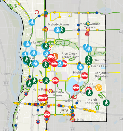
or click on the image above to leave your comments.
Review the Plan
The City has completed the safety analysis of the City's roadway network. Review the safety analysis and draft plan here(PDF, 5MB) .
More Information
- Fridley Streets For All Informational Flyer(PDF, 790KB)
- (PDF, 790KB)2020 Active Transportation Plan (2nd Edition): Public feedback collected in 2019 was used to develop the current edition of this plan resulting in construction of identified priority segments including: the University Avenue trail, the 44th Street Bridge trail, the 7th Street trail, the 53rd Avenue trail, and the upcoming Mississippi Street trail (East River Road to University Avenue NE to be constructed in 2026), the 7th Street trail extension (61st Avenue NE to Mississippi St to be constructed in 2026) and the 61st Avenue trail (University Avenue NE to West Moore Lake Dr to be constructed in 2026).
- Safe Streets for All Program: The federal Safe Streets for All program supports municipalities in planning for and implementing transportation projects to help meet the US Department of Transportation's goal of zero roadway deaths. Completing a Streets for All plan allows the City to submit applications for grant funding through this program.
Questions
Please submit questions or comments to Rachel Workin, Environmental Planner at 763-572-3594 or email Rachel.
Si necesita ayuda de interpretación o traducción gratis, comuníquese con el personal de la ciudad.
Yog tias koj xav tau kev pab txhais lus los sis txhais ntaub ntawv dawb, ces thov tiv tauj rau Lub Nroog cove neeg ua hauj lwm.
Haddii aad u baahan tahay tarjumaad bilaash ah ama kaalmo tarjumaad, fadlan la xiriir shaqaalaha Magaalada.